At 5:10am, my alarm went off. I had already packed a day pack full of food and just had to jump into my car. The dashboard read 39 degrees. I love how many times the day and night temperatures vary by 40 degrees here.
I started driving toward town and dutifully went 45 miles per hour, the nighttime speed limit. About fifteen minutes down the road, I had to slam on my breaks for two buck mule deer who came jumping out of nowhere. When I finally reached town, I began by eating breakfast in my car while I waited for Christy, a fellow grad, and Marc to come out.
In no time, we piled into Marc’s van and headed into the Elk Refuge. The rough road went okay until we turned up Curtis Canyon and then the going went a little slower. We wound upward through the Elk Refuge into the National Forest past tents and large pot holes. Reaching the trailhead, we all breathed a sigh of relief.
Throwing on our packs we began up the trail. The first uphill slog, fireweed, indian paintbrush, tobacco brush, and sagebrush surrounded the trail.
“Wait. If I’m hiking with two TSS grads, does that mean double the dorking out along trails?” Marc asked.
“Yes!” Christy and I both laughed.
Soon after, we topped a ridge covered in conifers. We chatted back and forth listening to the red squirrels and trying to see how many wildflowers we could identify. We saw no one. Along the way, we saw a grouse and heard many pika. Not long after the pika in the talus, we went into the Gros Ventre Wilderness.
After roughly three total miles, we got to Goodwin Lake. A few people sat camping a little ways off the lake – the first people we saw all morning. We took an extended snack break and used it as an opportunity to examine the map. We knew that we needed to stay on the north side of the lake, then take a climbers trail that split off to the east. The internet said the side trail would split about half a mile after the lake.
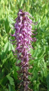
Setting off, we ran into a side trail splitting east almost instantly, but it seemed to only circumnavigate the lake. We poked around to look, just in case and found some brilliant elephant head flowers. Marc laughed as Christy and I examined it more closely.
We kept hiking for more than half a mile and began to examine the southern ridge. The northern ridge that we approached before the lake looked like a lot of unstable scree, so we did not think that the trail would go up there. On the way, we saw fields full of purple lupines and a white humble flower which we could not identify.
“Whoa! Mandy! Look at that banding!” Christy exclaimed mid conversation and pointed.
“Holy metamorphic rock!” I replied finding it.
Marc stopped, turned around, and said, “Really?!”
“It’s awesome!” Christy said.
“That’s the kind of example you hope to find to show students because the banding is so obvious,” I said.
At that point, we looked up at the southern ridge and discussed how we planned on going up. We knew if we could get to the top of it, we could hike straight to the summit. The question was, do we go straight up or do we look for a way to switchback our way up? We decided to head down the trail a little bit further to get a better vantage point.
Not even five minutes up the trail, the side trail split off with a cairn switch-backing up the ridge steeply. We laughed at how obvious the trail was. We headed upward toward the southern ridge taking breathers to look at the map and pick out the surrounding peaks in the Gros Ventres.
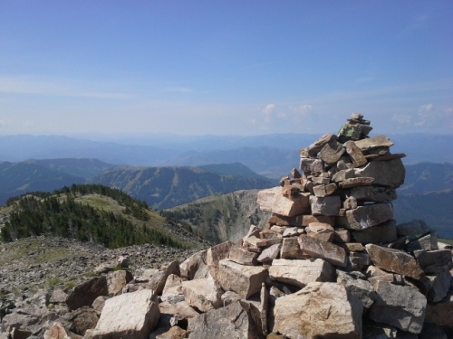
We could see the summit. We had heard that the last 100 feet or so to the summit was “a bit of a rock scramble.” Lie. The trail turned to loose talus and scree for the last 50 or so feet walking, not 100 vertical feet. And it definitely was not a scramble…fun, but not a scramble. As the first ones on the summit, we set about taking photos and eating peanut butter and honey sandwiches.
About fifteen minutes later, we heard something. All three of us turned in the direction of the sound going silent instantly.
“Humans,” Christy said and we all went back to munching and ogling Sleeping Indian, the beautiful mountain to the north. After the other hikers came up, we helped each other out taking group shots, then we headed back down. We poked around at the flowers and found some more cool rocks with very apparent feldspar and quartz crystals imbedded in them. As we passed probably 20 more hikers, we all agreed that our early start was a good thing. We hit the summit at the right time with the right people.

